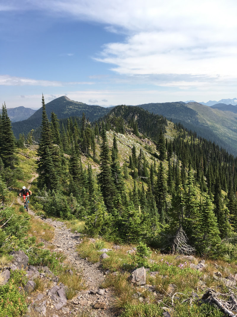
 The Taylor Hellroaring Project is a proposal to build a new network of trails on the Whitefish Face, to the north and west of Whitefish Mountain Resort. These trails would connect to the existing trails on Whitefish Mountain Resort and to the Whitefish Trail as well as to the network of trails to the north of the resort. FAMB has been instrumental in crafting this proposal and strongly supports this project. FAMB submitted comments in April, 2017. A summary of these comments appeared in a previous blog post on our website.
This month, FAMB submitted comments on the project Environmental Assessment (EA), in support of Alternative 2, which adds the most trails - approximately 40 miles of new trail. You can learn more about the project here. A map of Alternative 2, which FAMB supports, is here. A map of Alternative 3, which has a reduced number of trails, is here. Alternative 1 would be "no action" - no new trails built. The full text of FAMB's comment appears below: Dear Project Leader Bond, Please accept these comments regarding the Taylor Hellroaring Project EA from Flathead Area Mountain Bikers (FAMB), a nonprofit based in the Flathead valley, dedicated to preserving and enhancing mountain bike opportunities in the area. FAMB strongly supports the recreational opportunities afforded by Alternative 2, as it provides excellent opportunities for accessible recreation, and it creates a broader network that will allow users to spread out and thus avoid conflicts that can arise on crowded trails. Furthermore, the additional mileage of trails in Alternative 2 (as opposed to Alternative 3) goes further towards replacing the access that was lost by mountain bikers through the adoption of recommended wilderness areas in the recent Forest Plan revision. FAMB feels that, while there are undoubtedly impacts associated with trail networks and the use thereof, those impacts can largely be addressed via smart trail construction techniques. Those include (but certainly aren’t limited to) building proper sight lines, routing the trail so as to avoid sensitive areas, and promoting safe travel practices via education and signage. Notwithstanding the foregoing, and without diminishing FAMB’s support for Alternative 2, we feel that Alternative 3 could be laid out in a manner to better serve the recreating public and the goals of the project. First, and most importantly, we feel Alternative 3 should retain Trail 2. Trail 2 is an alternative access point into the network if access through private land cannot be obtained. This situation is the same in both Alternative 2 and 3; if access through private land cannot be obtained, the primary access into the network will necessarily be on Trail 2. Thus, if Alternative 3 is adopted as proposed without including Trail 2, and access through private land cannot be obtained, the network is effectively isolated with no reasonable point of access from the south. This would obviously be detrimental, and would substantially reduce the use and benefit of many of the trails. One of the stated concerns about Trail 2 is “multiple switchbacks,” however the EA does not actually explain why a trail with multiple switchbacks is problematic. Regardless, the trail could be re-oriented to reduce the number of switchbacks while still accomplishing the requisite connectivity. The other concern with this trail appears to be negative wildlife interactions, and specifically, grizzly bears. While we recognize that negative interactions with bears are a concern, as noted in the EA on page 3-178, Herrero and Higgins “found that incidents involving grizzly bears were more likely to occur in back country locations as compared to front country locations.” Given that Trail 2 is in close proximity to Whitefish Mountain Resort and is relatively close to houses in the Elk Highlands area, it would seem that it is located in the most “front country” location of all of the trails proposed. Thus, while negative bear interactions are certainly still a concern, based on the studies on the topic, it appears that the location of Trail 2 would indicate that it is less likely to be problematic. Given the importance of Trail 2 for connectivity in the event that a connection through private property is not possible, the trail should be kept in Alternative 3 as an alternative access point. Second, Alternative 3 removes trail L5, but keeps L7 and L8. We feel that this tradeoff is not ideal – L5, in conjunction with L3 and L6, creates a series of stacked loops that stretch from Hellroaring Creek to the ridgeline. We anticipate that these will be the most popular trails in the network, and they’ll receive the most use. Removing the upper portion of L5 negatively impacts this configuration because 1) it means L6 is the only connector to the ridgeline in the area, which means that all traffic will be routed on that trail corridor, effectively creating a choke point; 2) it removes any possibility of establishing (whether by rule or by defacto use) preferred directions of travel, since all traffic directions will necessarily use L6, and 3) we feel that creating a denser network in that area makes more sense in terms of wildlife impacts – it concentrates much of the use in one area, allowing wildlife to adapt and avoid that particular area. If trails are going to be removed from Alternative 2, we feel a better configuration is to keep L5 and remove L8. In this context, L8 refers to the northern trail labelled as L8 on the Alternative 3 map (there are two trails on the map labelled as L8). Third, Alternative 3 retains two trails at the northern end of the project (both labelled as L8 on the Alternative 3 map), but it removes Trail L9. We feel that L9 is ultimately more important to the network than the northern L8 trail. Trail L9 provides better access into the network from the northern end of the project area, and would better allow some users to access the trails from the north end of Taylor Creek Road. While we don’t anticipate that this will be a major access point for the network, it is nevertheless preferential over the Alternative 3 configuration where L8 is the northernmost access point along Taylor Creek Road. Thus, while we still support the inclusion of all trails as set forth in Alternative 2, we feel that the northern L8 trail could be removed, and Trail L9 should be kept. Fourth, Alternative 3 removes all trails to the west (downhill) of Taylor Creek Road in the area of trails L7 and L8. We feel this minor reduction in mileage comes at a high cost, as it will force all traffic in that area onto the Taylor Creek Road. While both Alternative 2 and Alternative 3 utilize Taylor Creek Road to create connections where necessary, Alternative 3 will put considerably more traffic on the road for much longer stretches. We’re concerned that configuration will not only create a less enjoyable experience for the trail users, but also will create potential conflicts with cars and other motorized traffic on the road. Furthermore, deleting these trails makes potential connections to areas to the west of the project area (e.g. future connections across private or DNRC lands) considerably more difficult. Given that the segments of trail to the west of Taylor Creek Road are relatively short, this attempt to reduce overall trail mileage of the project has a high cost with seemingly little benefit. Fifth, we feel that Alternative 3 falls short by removing both C3 and C4, on the north side of the ridgeline. While together, those trails create a good loop opportunity, a significant benefit of those trails is creating access to 316 Road, and thus access to the Smokey Range NRT. Absent those trails on the north side of the ridge, there is no practical way to access the Smokey Range trail, and given its designation as a National Recreation Trail and the fact that the Purpose and Need statement for this project specifically mentions connectivity to that trail, omitting C3 and/or C4 is particularly detrimental to that goal. By keeping C3 (but, perhaps, omitting C4, or vice-versa), the goal of providing accessibility to the Smokey Range NRT could be accomplished, albeit without the shorter loop potential offered by retaining both of those trails. With respect to Trails C3 and C4, the EA raises concerns about facilitating access to the Smokey Range Trail because easier access could mean the trail becomes a high-use trail in the future. While this concern seems somewhat at odds with the trail’s designation as a National Recreation Trail and the project’s stated Purpose and Need, it also seems unlikely that levels of use will increase to high levels. Even with the access that would be afforded by Trails C3 and C4, reaching the Smokey Range trail and travelling across it is still a significant and difficult journey that only a relatively small number of people will be able to undertake. From the trailhead, it’s still 14-15 miles with significant elevation gain just to get to the start of the Smokey Range Trail. In other words, even with the addition of Trails C3 and/or C4, the Smokey Range Trail is still a large and difficult adventure that will be beyond the abilities of most recreationists. Regardless of the alternative chosen or the specific trails approved, FAMB also has concerns about the suggested Implementation Actions and Timelines set forth in table 3-40. Given that many of the trails pass through areas where substantial logging activities will be occurring, we feel that the timelines need to better acknowledge the delays that may be associated with those harvests, as it makes little sense to construct a trail that would, shortly thereafter, potentially be damaged by logging operations. Furthermore, those same logging activities may create difficulties in flagging and laying out the precise locations of the trails. We feel these potential difficulties should be acknowledged at the outset, and a goal for implementation of the project should be the close coordination of logging activities and trail planning and construction. It also means that trails that are unaffected or minimally affected by logging activities may be the most appropriate segments to work on to begin with. Similarly, while we don’t take specific issue with any of the proposed actions with respect to logging, we feel that flexibility should be built into the trail proposals where the trails cross areas that will be logged. For example, Trail L5 crosses through significant areas that are proposed to be clear cut. It would make sense to re-orient the trail where possible to minimize the amount of trail corridor that passes through the clear cut area, because trails in clear cuts are less enjoyable for users, and they tend to be more difficult to maintain. Similarly, trails may need to be routed through these areas in a manner that utilizes anchor trees, or takes advantage of view points that might not have existed prior to the logging operations. While we don’t envision that these re-orientations would be major, it would be beneficial to consider the possibility of logging related changes to the trail configuration at this juncture. While these are somewhat less significant concerns, we also feel the project could be improved with the following changes: 1) We prefer the orientation of Trail 1 in Alternative 3, which avoids the wetland area. Alternative 2 should include that trail configuration. 2) While we prefer Alternative 2, we do not take issue with the trails in the Holbrook area that were removed in Alternative 3 due to landowner concerns. Specifically, we don’t take issue with removal of Trails L1B and C1 from Alternative 2. 3) The configuration of Trail L7 in Alternative 3 appears to be preferential to the configuration of L7 in Alternative 2. We suggest changing Alternative 2 with respect to that trail segment. 4) There appears to be an inconsistency with respect to Trail L8. There are two “L8’s” on the Alternative 3 map. The southern L8 segment is unlabeled on the Alternative 2 map. The discussion of the segment in Table 2-8 appears to be referring to the southern segment. We support the inclusion of both segments, as depicted on the Alternative 2 map. However, as noted in these comments, we feel that L5 and L9 are more important segments than the northern L8 segment. 5) Trail L9 could be slightly re-oriented to avoid the tributary to Taylor Creek (at the northernmost extent of the trail). By staying to the south of that creek, some concerns may be alleviated, and trail construction will be less complicated. Thank you for your work on this project and your time in considering these comments. FAMB looks forward to working with the Forest Service both through the approval and implementation stages of this project. The recreation opportunities that this proposal provides will be a tremendous asset to the community.
1 Comment
|
About UsFlathead Area Mountain Bikers, a 501(c)(3) nonprofit, is working to promote mountain biking and improve trail access in the Flathead Valley. Archives
June 2024
Categories |
 RSS Feed