|
In a letter to the editor of the Flathead Beacon, FAMB board member Noah Bodman applauds the Forest service approach to recreation. You can read the full text here, and we have pasted it below as well:
Forest Service Should be Applauded for Approach to RecreationThere’s no question that increasing use raises concerns about interactions with wildlifeBY NOAH BODMAN // JUL 27, 2019 Recreational use on our forests has increased tremendously over the last decade but the infrastructure to support that use hasn’t kept pace, and our trails are overcrowded. The solution is simple: we need more trails, and more trailheads. Thankfully, the Forest Service is working on projects like Taylor Hellroaring and Crystal Cedar that will go a long way towards meeting these needs. The incentives for these trails are clear: spreading out users will solve many of the overcrowding problems we see, and better recreational opportunities in the valley benefit the community as a whole. A Headwaters Economics Study in Whitefish estimated that “outdoor recreation generates $101.2 million in spending annually and contributes approximately 1,460 jobs and $41.1 million in income in the community.” Of course, the economics of the situation aren’t the primary reason for these trails. For many of us, a large part of the reason we live in the Flathead is because of the outdoor opportunities that the area offers. There’s no question that increasing use raises concerns about interactions with wildlife, specifically bears. And yes, we can do a better job educating people about taking precautions like carrying bear spray. But vocal opponents of these projects have adopted a “sky is falling” mantra with respect to mountain bikes that isn’t backed up by data – the fact is, bike/bear interactions are extraordinarily rare. That doesn’t mean reasonable precautions shouldn’t be taken, but banning bikes or trail runners is an overreaction. This is why Forest Supervisor Chip Weber’s approach to forest management should be applauded. Trail construction projects and event permits are analyzed with wildlife in mind, and reasonable precautions are taken. But after taking those considerations into account, much needed improvements to recreational amenities are moving forward, and the community as a whole will benefit. Noah Bodman, board member Flathead Area Mountain Bikers
1 Comment
Flathead National Forest Supervisor Chip Weber Pens Guest Column about Recreation in Wildland Areas7/26/2019 You can read this article at the source: https://flatheadbeacon.com/2019/06/28/risk-recreation-wildlands-offering-broader-perspective/
We also repost it here in its entirety: Risk and Recreation on Wildlands – Offering a Broader PerspectiveBalancing recreation, land management and conservation on public lands BY CHIP WEBER // JUN 28, 2019 For several years there has been an active dialogue regarding risks associated with recreation in wildlands and concern for the safety of people who choose to do so. Much of this discussion has been focused on interactions between grizzly bears and humans when running or mountain biking on trails. There is strong and expanding interest from the public in partaking in these activities (and many others) on the Flathead National Forest and other forested public lands. There are several proposed trail additions and events on the forest that have been the subject of much discussion. Public understanding could benefit from a broader discussion around these subjects than has been occurring. I think individual values are driving the discussion, not just for the public, but also for professional biologists I deeply respect. Biologists and bear management specialists who caution against running or mountain biking correctly base those concerns on bears’ response to “prey behavior” like running or their defensive reaction when surprised by something moving quickly toward them in the woods. There is a real risk when these things occur. I would like to offer a different way of thinking about that and other risks which occur when people recreate in the woods. There are several questions I would like to pose and, at least partially answer. First, how great are the risks of recreational activities in wildlands occupied by bears? What are the activities that pose the greatest risk and what is the relative risk of the biking and running people seem most concerned about? How do those risks compare to risks of other activities that commonly occur on the national forests? I will also offer a perspective on concerns about how these conflicts often do not go well for the bears involved. Finally, I want to discuss how I think we should consider risks in the context of the increasing demand for recreation on public lands and direction we have as an agency to provide welcome and access to the public on their national forests. I think important value differences are generating most of the conflict around how these lands should be used. Bears and people are increasingly coming into contact as bear populations grow, their geographic distribution expands, and people increasingly use the forests for recreation and other purposes. I looked at data on human fatalities from bear attacks available on Wikipedia that references each incident and the human activity associated with that attack. I limited my considerations to incidents occurring since 1990 because mountain biking and trail running weren’t very prevalent on the landscape prior to 1990. There have been 78 human fatalities from black bears and brown bears (which include grizzly bears) since 1990 in North America. Of those, 37 percent were associated with hiking or walking, 12 percent hunting, 4 percent fishing, and 1 percent tending fence on horseback. So, 54 percent of the fatalities were associated with slow quiet activities The next most frequent was camping at 19 percent. These attacks are often associated with food storage issues. They may occur in remote quiet settings or more noisy developed campsites, so I considered them separately. About 8 percent of fatal bear attacks occurred at people’s homes. There were a variety of other activities that only rarely resulted in bear caused fatalities, including mountain biking 3 percent and running 4 percent. This information at least begs the question of whether limiting folks to enjoying only slow, quiet activities in areas where bears are present provides any greater safety for people or bears. There are many steps we can take that can lower (not eliminate) risk of a bear attack. Some of these are included as guidelines or desired conditions in our Forest Plan. Specific trail locations and design, increased sight distances and bear awareness education are examples. What is the relative risk to bears from this? The Northern Continental Divide grizzly population has steadily increased at 2-3 percent per year and their geographic distribution has doubled over a ten-year period, even as human use of the Forest has rapidly increased. Black bears continue to thrive across the landscape. Very few bears have been euthanized following conflicts with bikers or runners on trails even as compared to conflicts from other trail uses. Food conditioning conflicts remain the most common issue resulting in bears having to be removed. While it is true that individual bears can lose their lives from trail user conflicts, this is not an issue significantly affecting population growth which remains robust. How does the risk you are exposed to in these activities compare to other recreational activities that occur on the national forests? What about rafting, boating, swimming, or fishing? Each of these activities has broad acceptance to occur on national forests, often in very wild and remote settings. From 2005-2014, there were an average of 3,536 fatal accidental drownings (non-boating related) annually in the United States — about ten deaths per day. An additional 332 people died each year from drowning in boating-related incidents. We do many things to try to promote water safety, but we don’t tell folks to stay away from the water. So why such a different reaction to the much lower risks from wildlife encounters? These are low probability, high consequence events. Deaths from grizzly attacks are horrific. We have a visceral response to that imagery that makes the probability of it happening seem much higher than it is. Activities like driving account for many more deaths, still, driving for pleasure is the number one recreational activity in the country. We normalize risks from these activities because accidents and deaths occur so much more frequently. For a more familiar example, people feel safer driving (fairly high risk) than flying (very low risk). I would suggest that we consider these different activities on an equal basis in the context of their relative risks when promoting recreation on national forests and other wildlands. All of that said, I think this conversation needs to address an entirely different aspect of risk, namely, who gets to decide what risks anyone takes in their recreational pursuits. I like to make those choices for myself and I want you to be able to do so as well. Thrill seekers enjoy activities like whitewater rafting and kayaking, rock climbing, hang gliding, downhill and backcountry skiing, and riding challenging trails. The joy of these experiences provides great quality of life for both locals and visitors. The economic benefits from this are expressed directly in local communities and indirectly by making this a desirable place to live. How will we, as a society, decide these questions? Do we want our decisions to reflect a narrow range of values, where only a certain, few, “approved” uses of public lands may occur? As bears expand their territories, do we want to increasingly put more and more public lands off limits to recreation that comes with risks? We have a forest plan that seeks to provide the “greatest good for the greatest number,” valuing all of these uses and providing places for awesome front-country uses like biking and running as well as amazing, quiet and solitude in world class wilderness. I hope we will continue to value it all. We are continuing to bring forward projects that enhance recreational enjoyment and access on the forest. As you think about this, I encourage you to stay engaged. You can inform yourself of the risks associated with your recreational pursuits, learn how to mitigate them to the extent possible, choose what to do based on your own values and own the consequences of your choices. I expect this debate will continue. In the meantime, we welcome you to your lands! Chip Weber serves as the Forest Supervisor for the Flathead National Forest. 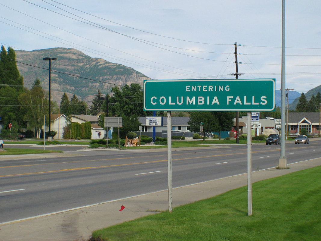 Following are FAMB's comments on the Crystal Cedar EA.
July 2, 2019 Dear Ms. Canepa, Please accept these comments from the Flathead Area Mountain Bikers (FAMB) regarding the Crystal Cedar environmental assessment. FAMB strongly supports the proposed action and the recreational aspects of this project. As we have stated in previous comments, the proposed network will provide something that is needed in Columbia Falls area, and it will be a tremendous resource for the community. Without diminishing FAMB's support for the project, there are a number of points we would like to make. First, we feel the proposed action is missing an opportunity to address current and future use issues by declining to incorporate mountain bike specific trails. For the recreational aspects of this project, mountain bikers have been heavily involved in the project from the outset. It was members of FAMB and the International Mountain Bike Association that met with Chip Weber years ago to discuss the possibility of trails in the Columbia Falls area. It was FAMB that carried out many of the early discussions with the Forest Service about this project. And when FAMB passed the torch to the Gateway to Glacier group to help lead the public outreach for this project, it continued to be mountain bikers that were the most heavily engaged and involved. There is a reason that mountain bikers have been so heavily involved: it's because, despite mountain bikers being one of the largest user groups in the area, there are very few trails in the Flathead Valley that actually cater to bikes. Multi use trails aren't bike trails, and ultimately, multi use trails are perfect for no one. While we understand the efficiency of building one trail for all user groups, given that mountain bikers have put a tremendous amount of work into this project, it seems clear that the interest exists to support the construction trails that are specifically designed with bikes in mind. Similarly, there is plenty of evidence on trail networks elsewhere in the valley as to the user conflicts that will exist if all users are directed onto non-directional, non user specific trails near trailheads. The trails within a mile of a trailhead will see considerably more use than the rest of the network, and as stated in our prior comments, we feel that additional trails that separate user groups in the area of the 4th Ave Trailhead are worthwhile. As the network is currently envisioned in that area, frequent user conflicts are likely. Other networks in the valley are being modified to address this sort of issue by adding trails in the vicinity of the trailhead and separating users, so it seems illogical to not address the issue from the outset in this network. Beyond these concerns, there are a number of areas where we feel the EA could be improved. First, on page 103, we feel that the EA overstates the current state of frontcountry summer recreation. The EA states "National Forest System lands in the project area currently offer a variety of frontcountry summer and winter recreational opportunities, including, but not limited to, dispersed camping, hiking, mountain biking, snowshoeing, motorized trail riding, snowmobiling, and Nordic skiing." This is not true. There is virtually no frontcountry recreation on the National Forest in the Columbia Falls area. The only trailhead in the immediate vicinity is the Columbia Mountain Trail, which is a singular trail that offers limited opportunities. The next closest trails would be those on Whitefish Mountain Resort, which aren't actually all that close to Columbia Falls, and many of which require paying for a lift pass. Outside of the Columbia Mountain trail and the WMR trails, there are few, if any trails or trailheads on Forest Service land that could be categorized as "frontcountry" within a 45 minute drive of the project area. On page 12 of the EA, Table 3, we would like to see the trail class designations of trails TR05, TR06, TR08, and TR10, be changed to class 2/3 (i.e. leaving the option open to make those trails fit either class 2 or class 3). This allows greater flexibility in the final design and construction of the trails in two respects. First, it would allow the trails to be built in a manner that created a defacto direction of travel. For example, if TR07 is built as a machine built trail with a 6% grade, and TR08 is a more natural, hand built trail with a 10% grade, the flow of travel for the vast majority of higher speed bike traffic will be to ascend TR07 and descend TR08, which benefits all users by creating a predictable pattern. Trail TR07 already has this flexibility by showing trail class 2, built for pack and saddle. But TR08 does not, and thus it may be more difficult for the trail builder to actually construct the trail in the most rational way. In this regard, and to reiterate a point from FAMB’s prior comments, the southern portions of TR07 should be built so that bicycle traffic on it is primarily in the uphill direction, with descending bike traffic routed to TR08 or the northern extent of TR07. Most likely, horse and foot traffic will use TR07 as an “out and back,” going to the view point at the top of the ridge, and then returning down the trail, at least to the intersection with Road 10810. Given that type of use, it is logical to direct higher speed descending bike traffic away from that trail. If bike traffic is directed down the southern portion of TR07, there will almost certainly be frequent conflicts with other users. The best way to avoid that is to build a bike only descent down the southern face of the ridge, as FAMB suggested in its prior comments. But if that’s not an option, at the very least, TR07 and TR08 should be built with a directional flow in mind, and changing the trail class of TR08 is one step in that direction. Similarly, a more natural, rougher trail will effectively slow mountain bikes down. While there are quite a few methods for reducing bike / wildlife conflicts, this is one method that is effective and can create more interesting, enjoyable trails for the riders. Additionally, short, steep pitches can actually have the effect of slowing riders down - riders perceive the change in pitch as an obstacle and approach it more hesitantly. As it is currently written, the EA emphasizes clearing vegetation to increase sight distances in order to reduce wildlife conflicts. And while clearing vegetation and increasing sight distances is certainly useful in reducing wildlife conflicts, long sight distances also often allow bikers to achieve higher rates of speed, which may not be desirable due to wildlife and user conflict concerns. Building an arbitrarily tight, turny trail can reduce that issue, but it comes at the cost of making the trail significantly less enjoyable to ride. The BLM’s Guidelines for a Quality Trail Experience (attached) does an excellent job of discussing this dynamic and laying out the design criteria that make for an enjoyable trail that riders will want to use repeatedly. But many of the design elements discussed in that document would be hindered by a trail class 3 designation - more options are left on the table with a trail class 2 designation, that allows for a rockier, rootier trail with more obstacles to slow traffic down. Finally, we feel that the EA should be more explicit in stating that the map of the trails is intended to show the general layout of the network, and the final location of the trails may be different. Final trail layout would be dictated by terrain, trail class, designed use, and a wide variety of other on-the-ground factors, and thus the layout may change significantly from the precise locations shown on Map 2. Thank you for your time in considering these comments. FAMB looks forward to working with the Forest Service to implement this plan and build out a trail network that will serve the recreating public at large, and mountain bikers in particular. /s/ Erin Bodman President, Flathead Area Mountain Bikers In case you haven't noticed, there has been recent discussion in the local media about various forms of recreation (and bikes more specifically) in bear habitat. In case you haven't seen any of these articles, we wanted to post some of them here so you can catch up on what's being talked about.
A June 25, 2019 article from the Flathead Beacon: https://flatheadbeacon.com/2019/06/25/conservation-group-hopes-stop-flathead-foot-races/ A June 26, 2019 article from MTPR.org: https://www.mtpr.org/post/recreation-hot-delisting-cold-goverments-grizzly-conversations Comments made by Chip Weber, Flathead National Forest Supervisor, on Wildlife and Risks to the Interagency Grizzly Bear Committee on June 25, 2019: https://m.facebook.com/notes/the-forest-service-flathead-national-forest/chip-webers-comments-on-wildlife-and-risks-given-to-the-interagency-grizzly-bear/2117577698351850/ Unfortunately, sometimes when one (or a very few) voices are louder than the rest, those voices get lots of attention, which is what we believe is going on here. We urge all mountain bikers, trail runners, and all other users who enjoy recreating, both alone and in groups in the National Forest: make your stance known when the Forest Service seeks comments for proposed and ongoing projects. It takes just a couple of minutes to submit comments, and every comment is reviewed and considered by the Forest Service before they make a final decision. Together, we can make it resoundingly clear that these very few loud voices do not represent the opinion of a majority of National Forest users! The Flathead National Forest requested public input on the issuance of temporary permits authorizing the Whitefish Trails Ultra-Marathon and Whitefish Shuttle Livery and Guiding on the Tally Lake Ranger District, the Foy’s to Blacktail Trail Marathon on the Swan Lake Ranger District and the Journey to Wellness Program on both districts. Both marathons would take place in MA 7 Focused Recreation areas. The projects would be authorized using 36 CFR 220.6(d)(8): Approval, modification, or continuation of minor, short-term (1 year or less) special uses of National Forest System lands.
Following are FAMB's comments, submitted to the US Forest Service on June 18, 2019: Dear District Ranger Mulholland, Please accept these comments from the Flathead Area Mountain Bikers (FAMB) in support of the issuance of permits for the Whitefish Trails Ultra-Marathon, the Whitefish Shuttle Livery and Guiding, the Foy’s to Blacktail Trail Marathon, and the Journey to Wellness Program. First and foremost, FAMB does not believe that a public comment period is necessary for the permits at issue. All of these permits fall squarely within the categorical exclusions set forth in 36 CFR 220.6(d)(8), 36 CFR 220.6(e)(3), and other categories described in Chapter 30 of the Forest Service Handbook. None of those categories require a public comment period. While there are clearly parties in the Flathead Valley that will jump at any opportunity to contest recreational ventures on the Flathead National Forest, the Forest Service need not be beholden to those extremist view points, and those minority opinions should not dictate the rational implementation of established Forest Service policy that benefits the vast majority of users with minimal impact. Notwithstanding the foregoing, FAMB supports the permits at issue. These are well run, well organized events and businesses that are operating in areas of the forest that are appropriate for the activities at issue. All of these permits cover well established trails that see high levels of use. The occurrence of these permitted activities will not have a significant impact on the overall level of use for the subject areas. Ultimately, these permits provide excellent ways for the public to use their public lands in a responsible, well organized manner. As FAMB has stated in the past, the public's appreciation for our national forests is something that must not be taken for granted, and the best way to foster such an appreciation is to get people out in the forest and enjoy everything that our public lands has to offer. One of the best ways to do that is to support events and businesses that help people get out on the Forest, and these permits do exactly that. For these reasons, FAMB strongly supports the issuance of these permits. Thank you, /s/Erin Bodman President Flathead Area Mountain Bikers, Inc. FAMB is recognized as a nonprofit organization under IRS Code 501(c)(3)  Following are the full comments submitted by FAMB in favor of the Taylor Hellroaring Project.
Dear Project Leader Mackenzie, Please accept these comments regarding the Taylor Hellroaring Project EA from Flathead Area Mountain Bikers (FAMB), a nonprofit based in the Flathead valley, dedicated to preserving and enhancing mountain bike opportunities in the area. FAMB strongly supports the proposed action, Alternative 2. We feel that the trails proposed within Alternative 2 will provide a much needed addition to the recreational offerings in the valley. Despite the abundance of Forest Service land in the vicinity of the Flathead Valley, there are very few trailheads accessing that federal land that are easily accessible from the population centers of the valley. The trail network laid out in Alternative 2 will provide excellent front and middle country recreation opportunities that connect with other area trails and are easily accessible from existing trailheads. The Forest Plan’s MA7 designation for the area is an acknowledgement that this area is appropriate for increased recreational use, and for good reason - the area is accessible, and its proximity to Whitefish Mountain Resort makes it a logical place for new trails. Furthermore, this trail network helps replace access that was lost to mountain bikers via recommended wilderness designations in the Forest Plan. Mountain bikers are one of the fastest growing user groups in the valley, yet they are the only user group that has lost substantial access in the last decade. This trail network will help correct a backwards policy of eliminating access for a popular non-motorized user group. Given that trail use in the valley has grown dramatically in the last decade, this network will take some of the pressure off of other trails and trailheads and also accommodate future increases in users. We feel that the layout of the network as set forth in Alternative 2 does the best job of providing that resource in a way that will work well for the most users. Without diminishing our strong support for Alternative 2 and the trails included therein, we feel that the EA is lacking in a few areas. First, we feel that there should be a clear statement indicating that the trails, as mapped, are for the most part not ground truthed. The final layout of the trails may deviate substantially from the trails as shown in the appendixes. The map of the trails accurately depicts the general concept and the connectivity that we envision, however the final layout will almost certainly change due to a wide variety of on the ground conditions. Similarly, while we don’t take specific issue with any of the proposed actions with respect to logging, we feel that flexibility should be built into the trail proposals where the trails cross areas that will be logged. The EA notes that forest clearing in the proposed trail corridors would be reduced to the extent practical through careful trail design and layout, which is an excellent idea. But in areas where that is not practical, it would make sense to re-orient the trail where possible to minimize the amount of trail corridor that passes through the clear cut area. For example, Trail L5 crosses through significant areas that are proposed to be clear cut, but trails in clear cuts are less enjoyable for users, and they tend to be more difficult to maintain. Similarly, trails may need to be routed through these areas in a manner that utilizes anchor trees, or takes advantage of view points that might not have existed prior to the logging operations. While we don’t envision that these re-orientations would be major, it would be beneficial to include language in the EA that allows for adaptability in trail design to work around logging activities. We would also like to see the trail class designations of trails L3, L4, L5, and L6 be changed to class 2/3 (i.e. leaving the option open to make those trails fit either class 2 or class 3). Those trails will likely see relatively high levels of traffic due to their proximity to the trailhead and Whitefish Mountain Resort, and they’re designed to create a set of “stacked loops.” The idea of the stacked loops is to create a mini-network that allows different users to go different distances without doing an “out and back.” The other benefit of the stacked loop arrangement is that the trails can be built to create a defacto direction of travel. For example, if L4 is built as a machine built trail with a 6% grade, and L3 is a more natural, hand built trail with a 10% grade, the flow of travel for the vast majority of higher speed bike traffic will be to ascend L4 and descend L3, which benefits all users by creating a predictable pattern. By showing the trail class for those trails as 2/3, it would leave the option open to tailor those loops as needed when laying out the trails on the ground. In other words, the EA should leave open the possibility for segments of trail that are steeper and/or rougher if ground truthing reveals that to be appropriate. Similarly, a more natural, rougher trail will effectively slow mountain bikes down. While there are quite a few methods for reducing bike / wildlife conflicts, this is one method that is effective and can create more interesting, enjoyable trails for the riders. Additionally, short, steep pitches can actually have the effect of slowing riders down - riders perceive the change in pitch as an obstacle and approach it more hesitantly. As it is currently written, the EA emphasizes clearing vegetation to increase sight distances in order to reduce wildlife conflicts. And while clearing vegetation and increasing sight distances is certainly useful in reducing wildlife conflicts, long sight distances also often allow bikers to achieve higher rates of speed, which may not be desirable due to wildlife and user conflict concerns. Building an arbitrarily tight, turny trail can reduce that issue, but it comes at the cost of making the trail significantly less enjoyable to ride. The BLM’s Guidelines for a Quality Trail Experience (attached) does an excellent job of discussing this dynamic and laying out the design criteria that make for an enjoyable trail that riders will want to use repeatedly. We feel that the trail class matrix is somewhat outdated when it comes to adequately describing trail characteristics for mountain bikes, and it does not capture the nuances involved in making a good trail that is interesting and fun to ride on a mountain bike while also being enjoyable for other users and also constraining use in a way that reduces wildlife conflicts. But even though the trail class matrix is deficient in that regard, it does not mean that such a trail can’t be built. Ultimately, the important point is to ensure that the trail class designations for the trails are not restricting the trail builders’ ability to create the best trail possible given the goals of the network and on the ground conditions. More specifically, the trail class designations should not serve as an impediment to speed controls via technical features (i.e. roots and rocks within the trail tread and changes in trail pitch). Trail class 3 states that “Obstacles may be common, but not substantial or intended to provide challenge,“ which will often mean that the trail class does not allow for sufficiently difficult obstacles to slow riders down. Thus our recommendation to allow for a Trail class 2 where appropriate, which states that “Obstacles may be common, substantial, and intended to provide increased challenge.“ As noted above, particularly on trails that are built with descending in mind, a trail class 2 designation will leave more options open to the trail builders to include design elements that will reduce riders’ speeds, and given the wildlife concerns in the area, keeping as many options available as possible seems appropriate. Notwithstanding the foregoing, and without diminishing FAMB’s strong support for Alternative 2, we feel that Alternative 3 could be laid out in a manner to better serve the recreating public and the goals of the project. First, and most importantly, we feel Alternative 3 should retain Trail 2. Trail 2 is an alternative access point into the network if access through private land cannot be obtained. This situation is the same in both Alternative 2 and 3; if access through private land cannot be obtained, the primary access into the network will necessarily be on Trail 2. Thus, if Alternative 3 is adopted as proposed without including Trail 2, and access through private land cannot be obtained, the network is effectively isolated with no reasonable point of access from the south. This would obviously be detrimental, and would substantially reduce the use and benefit of many of the trails. One of the stated concerns about Trail 2 is “multiple switchbacks,” however the EA does not actually explain why a trail with multiple switchbacks is problematic. Regardless, the trail could be re-oriented to reduce the number of switchbacks while still accomplishing the requisite connectivity. The other concern with this trail appears to be negative wildlife interactions, and specifically, grizzly bears. While we recognize that negative interactions with bears are a concern, as noted in the EA on page 3-178, Herrero and Higgins “found that incidents involving grizzly bears were more likely to occur in back country locations as compared to front country locations.” Given that Trail 2 is in close proximity to Whitefish Mountain Resort and is relatively close to houses in the Elk Highlands area, it would seem that it is located in the most “front country” location of all of the trails proposed. Thus, while negative bear interactions are certainly still a concern, based on the studies on the topic, it appears that the location of Trail 2 would indicate that it is less likely to be problematic. Given the importance of Trail 2 for connectivity in the event that a connection through private property is not possible, the trail should be kept in Alternative 3 as an alternative access point. Second, Alternative 3 removes trail L5, but keeps L7 and L8. We feel that this tradeoff is not ideal – L5, in conjunction with L3 and L6, creates a series of stacked loops that stretch from Hellroaring Creek to the ridgeline. We anticipate that these will be the most popular trails in the network, and they’ll receive the most use. Removing the upper portion of L5 negatively impacts this configuration because 1) it means L6 is the only connector to the ridgeline in the area, which means that all traffic will be routed on that trail corridor, effectively creating a choke point; 2) it removes any possibility of establishing (whether by rule or by defacto use) preferred directions of travel, since all traffic directions will necessarily use L6, and 3) we feel that creating a denser network in that area makes more sense in terms of wildlife impacts – it concentrates much of the use in one area, allowing wildlife to adapt and avoid that particular area. If trails are going to be removed from Alternative 2, we feel a better configuration is to keep L5 and remove L8. In this context, L8 refers to the northern trail labelled as L8 on the Alternative 3 map (there are two trails on the map labelled as L8). Third, Alternative 3 retains two trails at the northern end of the project (both labelled as L8 on the Alternative 3 map), but it removes Trail L9. We feel that L9 is ultimately more important to the network than the northern L8 trail. Trail L9 provides better access into the network from the northern end of the project area, and would better allow some users to access the trails from the north end of Taylor Creek Road. While we don’t anticipate that this will be a major access point for the network, it is nevertheless preferential over the Alternative 3 configuration where L8 is the northernmost access point along Taylor Creek Road. Thus, while we still support the inclusion of all trails as set forth in Alternative 2, we feel that the northern L8 trail could be removed, and Trail L9 should be kept. Fourth, Alternative 3 removes all trails to the west (downhill) of Taylor Creek Road in the area of trails L7 and L8. We feel this minor reduction in mileage comes at a high cost, as it will force all traffic in that area onto the Taylor Creek Road. While both Alternative 2 and Alternative 3 utilize Taylor Creek Road to create connections where necessary, Alternative 3 will put considerably more traffic on the road for much longer stretches. We’re concerned that configuration will not only create a less enjoyable experience for the trail users, but also will create potential conflicts with cars and other motorized traffic on the road. Furthermore, deleting these trails makes potential connections to areas to the west of the project area (e.g. future connections across private or DNRC lands) considerably more difficult. Given that the segments of trail to the west of Taylor Creek Road are relatively short, this attempt to reduce overall trail mileage of the project has a high cost with seemingly little benefit. Fifth, we feel that Alternative 3 falls short by removing both C3 and C4, on the north side of the ridgeline. While together, those trails create a good loop opportunity, a significant benefit of those trails is creating access to 316 Road, and thus access to the Smokey Range NRT. Absent those trails on the north side of the ridge, there is no practical way to access the Smokey Range trail, and given its designation as a National Recreation Trail and the fact that the Purpose and Need statement for this project specifically mentions connectivity to that trail, omitting C3 and/or C4 is particularly detrimental to that goal. By keeping C3 (but, perhaps, omitting C4, or vice-versa), the goal of providing accessibility to the Smokey Range NRT could be accomplished, albeit without the shorter loop potential offered by retaining both of those trails. With respect to Trails C3 and C4, the EA raises concerns about facilitating access to the Smokey Range Trail because easier access could mean the trail becomes a high-use trail in the future. While this concern seems somewhat at odds with the trail’s designation as a National Recreation Trail and the project’s stated Purpose and Need, it also seems unlikely that levels of use will increase to high levels. Even with the access that would be afforded by Trails C3 and C4, reaching the Smokey Range trail and travelling across it is still a significant and difficult journey that only a relatively small number of people will be able to undertake. From the trailhead, it’s still 14-15 miles with significant elevation gain just to get to the start of the Smokey Range Trail. In other words, even with the addition of Trails C3 and/or C4, the Smokey Range Trail is still a large and difficult adventure that will be beyond the abilities of most recreationists. Regardless of the alternative chosen or the specific trails approved, FAMB also has concerns about the suggested Implementation Actions and Timelines set forth in table 3-34. Given that many of the trails pass through areas where substantial logging activities will be occurring, we feel that the timelines need to better acknowledge the delays that may be associated with those harvests, as it makes little sense to construct a trail that would, shortly thereafter, potentially be damaged by logging operations. Furthermore, those same logging activities may create difficulties in flagging and laying out the precise locations of the trails. We feel these potential difficulties should be acknowledged at the outset, and a goal for implementation of the project should be the close coordination of logging activities and trail planning and construction. It also means that trails that are unaffected or minimally affected by logging activities may be the most appropriate segments to work on to begin with. We also feel that the implementation timeline doesn’t envision a more rapid build-out of the trail network if funding and resources become available. While it is to be seen if funding can be found for the construction of the trails, if funding is forthcoming and the construction of the initial trails goes smoothly, the implementation plan should accommodate a more rapid construction of the remainder of the network. Thank you for your work on this project and your time in considering these comments. FAMB looks forward to working with the Forest Service both through the approval and implementation stages of this project. The recreation opportunities that this proposal provides will be a tremendous asset to the community. Thank you, /s/ Erin Bodman Flathead Area Mountain Bikers President FAMB is recognized as a nonprofit organization under IRS Code 501(c)(3) 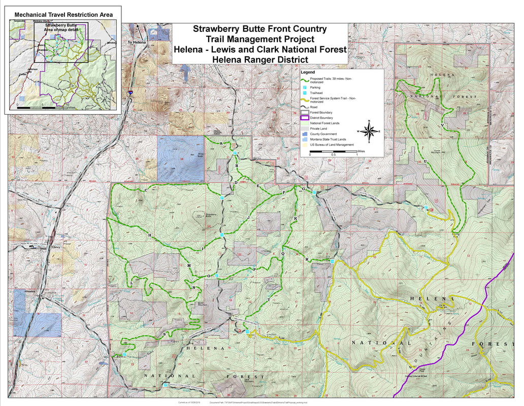 The Forest Service is looking at taking on the Strawberry Butte Frontcountry Trail Management Project. This is a trail system southeast of Helena that needs better management. Most of the trails are unofficial. The project would make about 28 miles of trail "official" and would build another 11 miles of new trail to improve the network.
Suggestions for your comments: -There is long-standing use in this area, and managing it in a constructive way is a good move. -Managing the trails for mountain bike use is important to me. -This will help disperse use from the Helena South Hills. -Doing this project under a categorical exclusion makes sense. Due Date: Submit your comments by November 30, 2018 How to Comment: Email your comments to: comments-northern-helena-helena@fs.fed.us and put "Strawberry Butte Front Country Trail Management Project" in the subject line. Include your name and address in your comments. Comments can be addressed to District Ranger Roy Barkley. More Info: https://www.fs.usda.gov/project/?project=54963 Trail access in the Bitterroot Valley (near Hamilton) is at risk. The Forest Service is trying to shut bikes out of the Blue Joint and Sapphire Wilderness Study Areas. The Bitterroot Backcountry Cyclists have put a ton of effort into saving these trails because they've been riding (and maintaining them) for years. We need mountain bikers to submit written objections to try to keep the Forest Service from shutting bikes out of 525 miles of trail.
Suggestions for your Objection: -There's virtually zero scientific evidence that mountain bikers are negatively impacting the environment in these areas. -These trails are remote, and use levels are low. User conflicts are essentially a non-issue. -Forest Service Region 1, and Montana in particular, has taken an anti-bike stance in Wilderness Study Areas, and that is at odds with similar discussions elsewhere in the country. -Mountain biking is a quiet, human powered use that is compatible with backcountry trails. The Forest Service should not shut bikes out of every remote and wild piece of trail. Due Date: Submit your Objections by November 19, 2018 How to Object: Email your comments to: appeals-northern-regional-office@fs.fed.us and put "Bitterroot Travel Plan Objection in the subject line. In the email, include your name, address, and phone number. More Info: The Bitterroot Backcountry Cyclists have a bunch more information about this on their website: https://sites.google.com/site/bitterrootbackcountrycyclists/news/talkingpoints?authuser=0 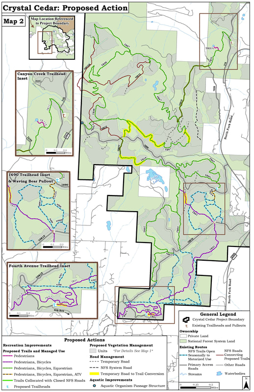 The "Crystal Cedar Project" is a proposal to do some forest management in the area immediately north of Columbia Falls, and that means some logging activities as well as building NEW TRAILS! The project has around 25 miles of new trails proposed, and should be a great network.
Suggestions for your comments: -I support this project because it'll offer a great resource for mountain biking, and it's something that's needed for the Columbia Falls community. -The project will help relieve pressure from other heavily used trail systems at the north end of the valley. -I'd like to see a bike specific trail included in the project, because it'll be a great resource, and it'll help reduce user conflicts elsewhere in the trail system -I support the comments submitted by FAMB (which include a bunch of other bike friendly suggestions for the project that are too detailed to wade into here). Due date: Submit your comments by November 16, 2018 How to comment: Email your comments to: comments-northern-flathead-hungry-horse-glacier-view@fs.fed.us with "Crystal Cedar Project" in the subject line. Include your name and address in your comments. Comments can be addressed to District Ranger Robert Davies More Info: https://www.fs.usda.gov/project/?project=52844&exp=overview (the documents, including maps of the trails, are under the "Scoping" tab). 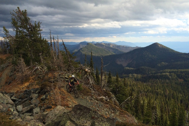 Good News!
The Forest Service released their final decision on the Hungry Lion project, and mountain bikes got a win! The Forest Service has added the Lion Lake and Desert Mountain trails to the official trail system. While these trails get a fair amount of use, they weren't "official," which meant that doing maintenance on them (and getting funding to do that maintenance) was complicated and difficult. This is a big step in the right direction for trail access in the canyon area, and FAMB will be working with the Forest Service to get those trails fixed up and to re-establish the climbing trail / loop option for Lion Lake. Thanks to everyone that submitted comments on this this project! Mountain bikers came out strong in support of this, and it made a difference! For anyone that has helped maintain these trails in the past, or wants to be involved in the maintenance in the future, shoot us a message. Here's the link to the official Forest Service page for this project: https://www.fs.usda.gov/project/?project=50134 |
About UsFlathead Area Mountain Bikers, a 501(c)(3) nonprofit, is working to promote mountain biking and improve trail access in the Flathead Valley. Archives
April 2024
Categories |
 RSS Feed